Get Closer to the Mountains Like Never Before
Give your outdoor outings a new dimension this winter. Whympr is going off the beaten path with the world’s most accurate HD winter satellite map of the Mont-Blanc area! But we didn’t stop there – we’re also releasing revolutionary 3D map enhanced with LiDAR technology, letting you explore every ridge, valley, and slope with unmatched precision. Curious to see how it will change your outings? We’ve got all the details in this article.
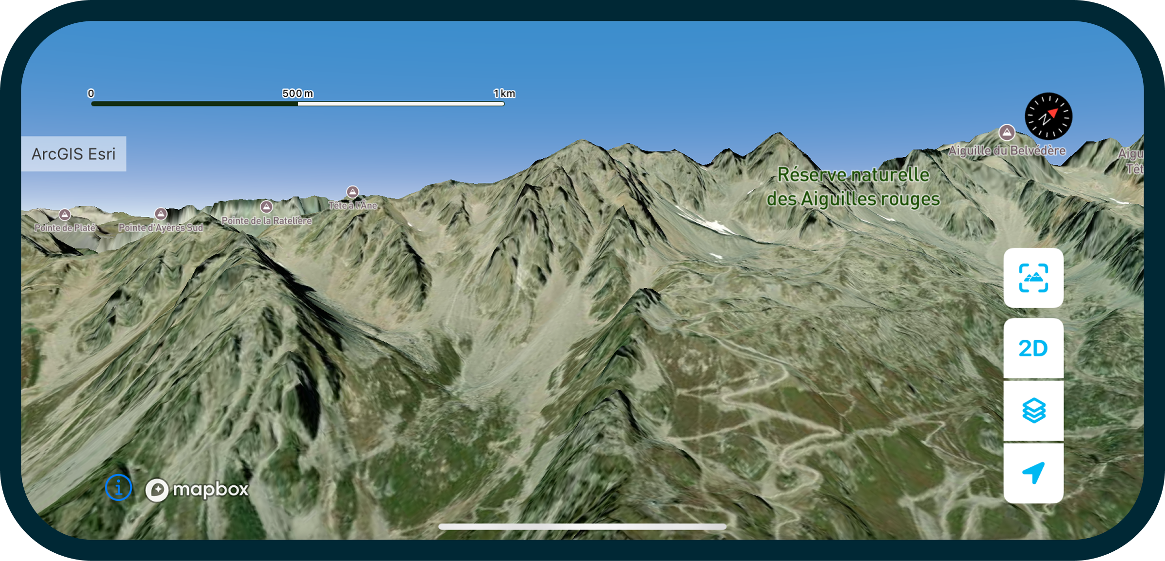
NEW Winter Satellite Map of the Mont-Blanc Massif
A Small Revolution in the World of Outdoor
What Whympr is offering this winter is nothing short of a small revolution in the world of winter satellite maps. Why? Because we’re making a technological leap that no other outdoor app has achieved yet. To create the best possible winter map by 2026, we made a bold move. In February 2025, we launched satellites to capture high-definition photos of the area we had defined. The result: we now have the world’s finest commercial resolution for a satellite map, with 30 cm per pixel, along with some of the most recent winter imagery available, dating from February 2025.
30 cm per Pixel – What Does It Mean?
A resolution of 30 cm per pixel means that each pixel on the map corresponds to 30 centimeters on the actual terrain. The smaller the number per pixel, the more precise the image, making it easier to analyze the terrain, plan your routes, and prepare for your outings. This level of accuracy provides an almost real-life experience.
What It Means for You
In practice, this allows you to see extremely fine details: a crevasse, a bump, a snow couloir, or even a skier’s track appears clearly on the map. Zoom in on areas like Les Grands Montets, the Vallée Blanche, or legendary couloirs to see for yourself.
More Than a Map, an Experience
Of course, this map is designed to help you plan your outdoor adventures. But let’s be honest, you might also find yourself spending time simply admiring your favorite mountain ranges, escaping, and dreaming. After all, that’s part of the promise too: bringing you closer to the mountains.
Winter Satellite Map Available for the Mont-Blanc Massif (for now)
Why Mont-Blanc first? It’s our birthplace, the starting point of Whympr, and one of the most challenging and iconic outdoor playgrounds in the world. So it’s only natural that our HD winter satellite map makes its first appearance in the Mont-Blanc area. Why Not Elsewhere yet? Quite simply because satellite imagery is very (very) expensive. As a startup, we cannot yet afford to cover all mountain ranges immediately. But we won’t stop here !
👉 And this is where your opinion matters: tell us which mountains we should map next!
By answering this short survey, you’ll help shape the future of the Whympr adventure.
Our ambition is clear: to gradually expand coverage to other iconic mountain ranges. But to do this, we need to validate the model. The more of you who purchase and test this new winter map (included in the Premium subscription), the faster we can launch new satellites over all the major mountain ranges. That’s why we invite you to join the adventure now: the more subscribers we have, the quicker we can expand and enhance coverage.
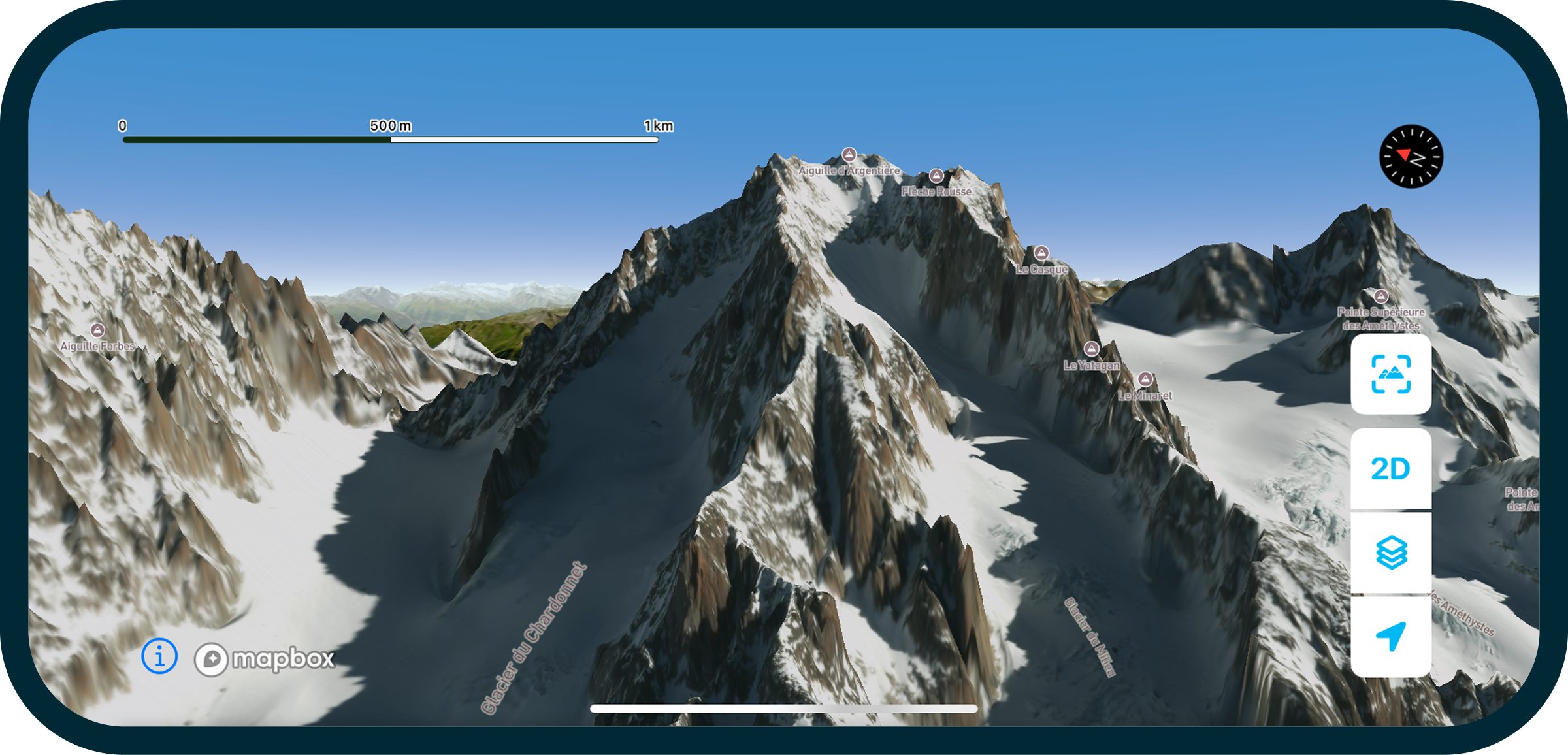
An Ultra-Precise 3D Map Powered by LiDAR
LiDAR Technology for the Outdoors
This is the brand-new generation of 3D maps. It’s based on LiDAR technology (Light Detection and Ranging), which uses laser light pulses to measure distances between the sensor and objects or surfaces. Thanks to this, LiDAR can produce highly detailed 3D maps of terrain, buildings, forests, roads, and even moving objects.
Visualize Terrain Variations
In practice, this density of data allows you to see topographic variations that standard maps cannot: ridges, crests, slope breaks, rock formations, and even crevasses. This level of detail greatly enhances terrain analysis, route planning, and understanding of the landscape in real conditions.
Digital Terrain Model
At the same time, the digital terrain model (DTM) used in Whympr offers a horizontal resolution of 1 meter and a vertical resolution of 10 centimeters, compared to most outdoor apps, which typically have a horizontal resolution of 30 meters and a vertical resolution of 10 meters.

Gradual Availability in France and Europe
LiDAR technology is available on Whympr for most maps in France and Europe (except for some flat areas) and will gradually be expanded to other countries.
All Included in Your Whympr Premium Subscription
And the good news: all of this is already included in your Whympr Premium subscription. No hidden fees, no add-ons – you get the winter satellite map and new features directly with your €24.99 subscription. One price, an enriched experience, and mountains opening up to you with unprecedented detail.
A Note for Former FATMAP Users
We know the disappearance of FATMAP left a void. It’s been over a year now, and many users have felt a bit lost (hello Leo Slemett 👋).
However, know that many of them have found a new home with Whympr. This winter might be the perfect time for you to really turn the page and try an app born at the foot of Mont-Blanc, developed by a small French team that lives, breathes, and dreams mountains every day. 😇
This Is Just the Beginning
Outdoor sports are far from trivial. They take place in demanding environments, and that’s what makes them beautiful. Our role is not to simplify them, but to provide you with the best digital tools to prepare properly. Because the more solid your preparation, the smoother your experience and the lower the risks. But let’s never forget: reading the terrain, observing conditions, and staying attentive are all part of the adventure. Digital tools are powerful allies, but they will never replace your eyes, your judgment, or the guidance of a professional.
The new features we’ve developed follow the same spirit as all the tools Whympr already offers to make planning outings easier worldwide: over 100,000 route descriptions, route creation, community feedback, professionally-made guides, outdoor weather, webcam access, real-time avalanche reports… and much more.
Ready to Explore the Outdoors Differently?
This winter, Whympr transforms the way you experience the outdoors. With the new HD winter satellite map, the ultra-precise 3D LiDAR map, and all the Premium features already included, every outing becomes more immersive, clearer, and richer. Whether you’re a hiker, skier, mountaineer, or simply a lover of outdoor sports, it’s time to get your Premium subscription and join the adventure.