Do you love backcountry skiing but not so much the lift lines? Do you have the legs for the descent and the cardio for the climb? And most importantly, do the Mont Blanc massif and its legendary routes around Chamonix make you dream, just as much as the more hidden spots?
Good news: Éditions Vamos has the guide for you. The book Backcountry Skiing Around Chamonix brings together a selection of both iconic and off-the-beaten-path routes, perfect for exploring one of the most beautiful playgrounds for backcountry skiing in the Alps.
We cover all the details in this article.
Written by Clément Guillot, president of the CAF of Chamonix and a certified mountain guide, and Christophe Lelièvre, warden of the Couvercle refuge, this book gives you all the keys to explore Chamonix and its surroundings. Don’t worry—just because Éditions Vamos specialize in Mont Blanc doesn’t mean they’re biased! This guide includes ideas not only for Chamonix, but also for the Beaufortain, Italy, Switzerland, and many other areas.
You’ll find everything you need for memorable mountain outings: elevation gain, difficulty ratings, maps, route descriptions, photos, and directions to the starting points. The difficulty ratings don’t exceed AD (fairly difficult), so if you follow the guide properly, you shouldn’t end up in a 50° couloir.
Do you really know backcountry skiing?
Did you know humans have been skiing for 4,000 years? Originally from the Ural region, backcountry skiing arrived in the Alps first as a means of transportation and later as a way to explore the mountains. The first ski raid dates back to 1897, a traverse of the Oberland.
After the boom of alpine skiing and the rise of ski resorts worldwide, backcountry skiing has seen a renewed interest. Remember during the Covid-19 pandemic, when lifts were closed—everyone turned to backcountry skiing!
Whether you want to explore a mountain range over several days, climb at full speed with lightweight skis, or reach a secret slope far from the crowds, there are countless reasons to get into backcountry skiing.
Today, the discipline has branched into several practices:
- Ski mountaineering, focusing on uphill with small, light skis
- Freerando, carrying heavier, wider skis (or worse, a splitboard) uphill for an amazing downhill experience
- Ski raids, where you go for multiple days and sleep in mountain huts
- Or the classic day outing, a mix of the above, finishing with a cold beer at the end
In fact, you can practice backcountry skiing almost anywhere in the world. While the Alps, Canada, the USA, Nordic countries, and Japan are well known, did you know you can ski in Morocco, Kyrgyzstan, or even Turkey?
Here, we’ll stay on the Mont Blanc side, but the world is vast and many places remain to be explored.
All the information for Chamonix… and beyond
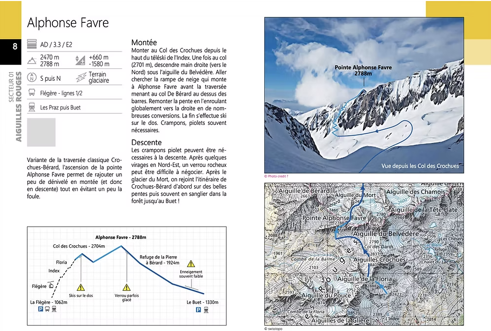
Thanks to the Vamos guidebook Backcountry Skiing Around Chamonix, you can find information on the big classics (Col du Tour Noir, Mont Blanc via the Grands Mulets, or on the Aiguilles Rouges side, Col des Dards) as well as lesser-known routes (loop around the Aiguilles des Angroniettes, West Couloir of Malatra, etc.).
Names are great, but the information is what counts. Right at the beginning of the book, you’ll find plenty of tips, such as what gear to take for glacier skiing and some basic avalanche safety knowledge.
Once you’ve applied anti-slip wax to your skins and practiced avalanche rescue drills, it’s time to embark on the quest for the most beautiful, untouched, and safest wild routes. Lucky for you, the book contains 80 outing ideas! Whether in Chamonix itself or within an hour of the city, there’s something for everyone.
The book is divided into eight areas across three countries: Aiguilles Rouges, Mont Blanc, Argentière le Tour, Les Contamines-Montjoie, Aravis/Beaufortain, Chablais/Fiz, Valais, and Vallée d’Aoste. The difficulty ratings do not exceed AD+.
Of course, difficulty isn’t just about ratings. Elevation gain, distance, exposure (E1, E2, E3, etc.), and all the climatic and human factors on the day also matter.
You can already select from long adventures (e.g., Mont Rogneux), shorter outings with great skiing and beautiful scenery (Croisse Baulet), or steeper slopes (Col des Droites).
Information included:
- A graph of the route with slope details and notes on common conditions (often icy, ski carrying required, sometimes low snow, etc.)
- A map (IGN or Swisstopo) with the route
- A photo with an illustration of the outing
Convinced? Here’s a link to order Backcountry Skiing Around Chamonix.
Hard to get more complete than this! Or… what if you could have all this information on your phone? 😉
And what about digital?
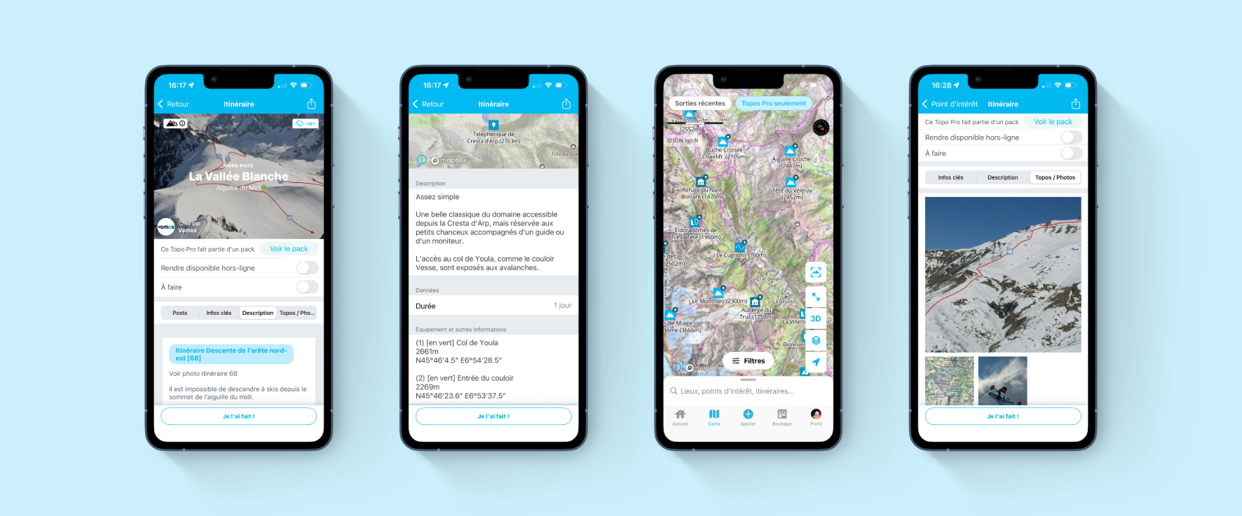
Whympr Pro Topos
These guides or topos —and many more—are available in the app and are called Pro Topos.
First, what is a Pro Topo? It’s a guide written by professionals, with high-quality information, available for purchase directly in the Whympr app (either individually or in packs).
You can find the book Backcountry Skiing Around Chamonix and its 80 routes as a pack, but you can also buy individual routes or by area, for example the Argentière basin. Just like with paper guidebooks, a percentage of the sale goes to the authors.
The digital format offers many advantages: for backcountry skiing Pro Guides—but also for hiking, mountaineering, or snowshoeing—you’ll have access to GPX tracks of the routes.
You can also precisely find the guide you need, locate it on the map, and always have it with you in the mountains. With Whympr Premium, you get additional useful features for your Pro Topo, like offline access, weather and BERA (Avalanche Risk Bulletin) display for each route, and many other tools.
Éditions Vamos, which is part of the same company as Whympr, combines paper and digital formats, which we see as complementary. That’s why when you buy a Vamos guidebook, you automatically get its digital version in Whympr for free!
If you want to learn more about Pro Topos, check out our blog article. You’ll find the full list of Pro Topo available in Whympr: rock climbing in the Verdon, hiking in the Calanques, mountaineering in Belledonne, and more. You’re sure to find something for you.
Whympr: the app for backcountry skiing!
These Pro Topos are available exclusively in Whympr, making it the perfect opportunity to discover all the app’s features designed for backcountry skiing.
Most of these features are included with a Whympr Premium subscription (€24.99/year). Don’t hesitate to try it—you get a one-week free trial to decide.
Among the many tools in the app, designed for backcountry skiing but also for off-piste skiing, hiking, climbing, and mountaineering, here’s a selection of features you might find useful:
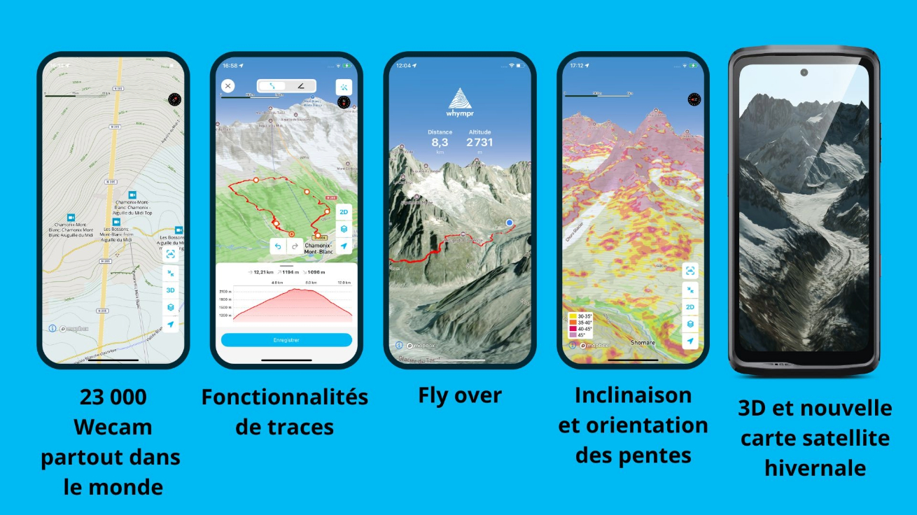
- Mapping: maps from around the world, including IGN (France) and Italian maps, plus the most up-to-date winter satellite map of the Mont Blanc massif. View in 3D and add layers (slope inclination and orientation, sensitive wildlife zones, etc.).
- Avalanche bulletins for Switzerland, Italy, France, Austria, the USA, and Canada, updated in real time, along with weather info (MeteoBlue) including history and forecasts.
- Over 100,000 routes and points of interest, including other Pro Guides.
- Activity filters to quickly find what you need.
- Track features (create, record, offline access, etc.).
- Peak View to visualize summits, 28,000 webcams worldwide, and a livestock guard dog map showing where the protection dogs are.
- Community features and the ability to create your own outing logbook.
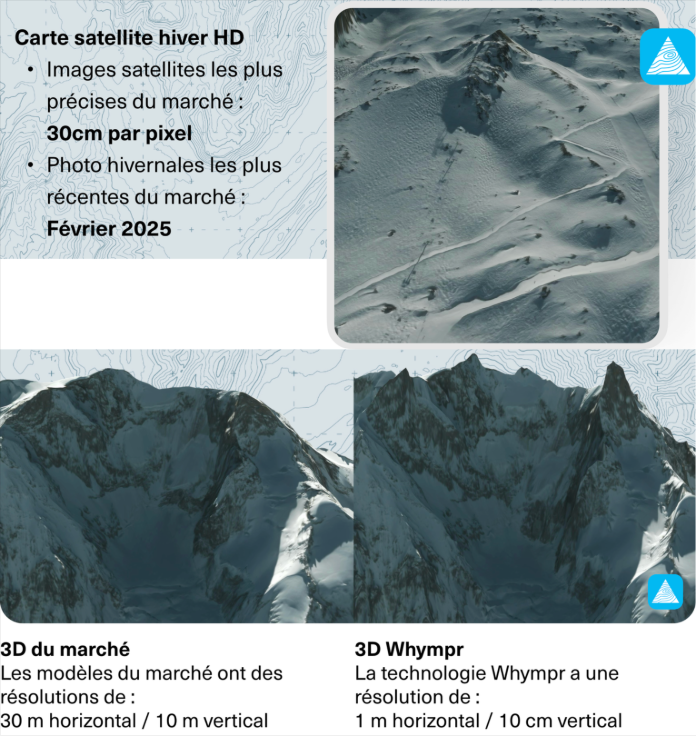
The most beautiful 3D satellite map of the Mont Blanc massif!
This is our big news for winter 2025/2026.
On December 4, 2025, we launched our new 3D satellite map of the Mont Blanc massif. Why the most beautiful? For two reasons.
First, the precision and image resolution. In February 2025, Whympr commissioned Airbus satellites to capture winter images of the Mont Blanc massif. The result: the most precise and up-to-date images available commercially. Proximity to the terrain is just 30 cm! You can even see ski tracks under the Col des Rachasses in the Grands and a few skiers on the Vallée Blanche.
Second, the accuracy of the 3D terrain. Relief is shown with 1 m horizontal and 10 cm vertical precision. The Dent du Géant has never looked so impressive on a map!
And in terms of price, the Whympr Premium subscription hasn’t increased—still just €24.99 per year.
A small selection of three outings tested and approved by us
At Whympr and Vamos, many of us spend a lot of time in the mountains. So we’ve put together a short selection of three outings we’ve tested and recommend:
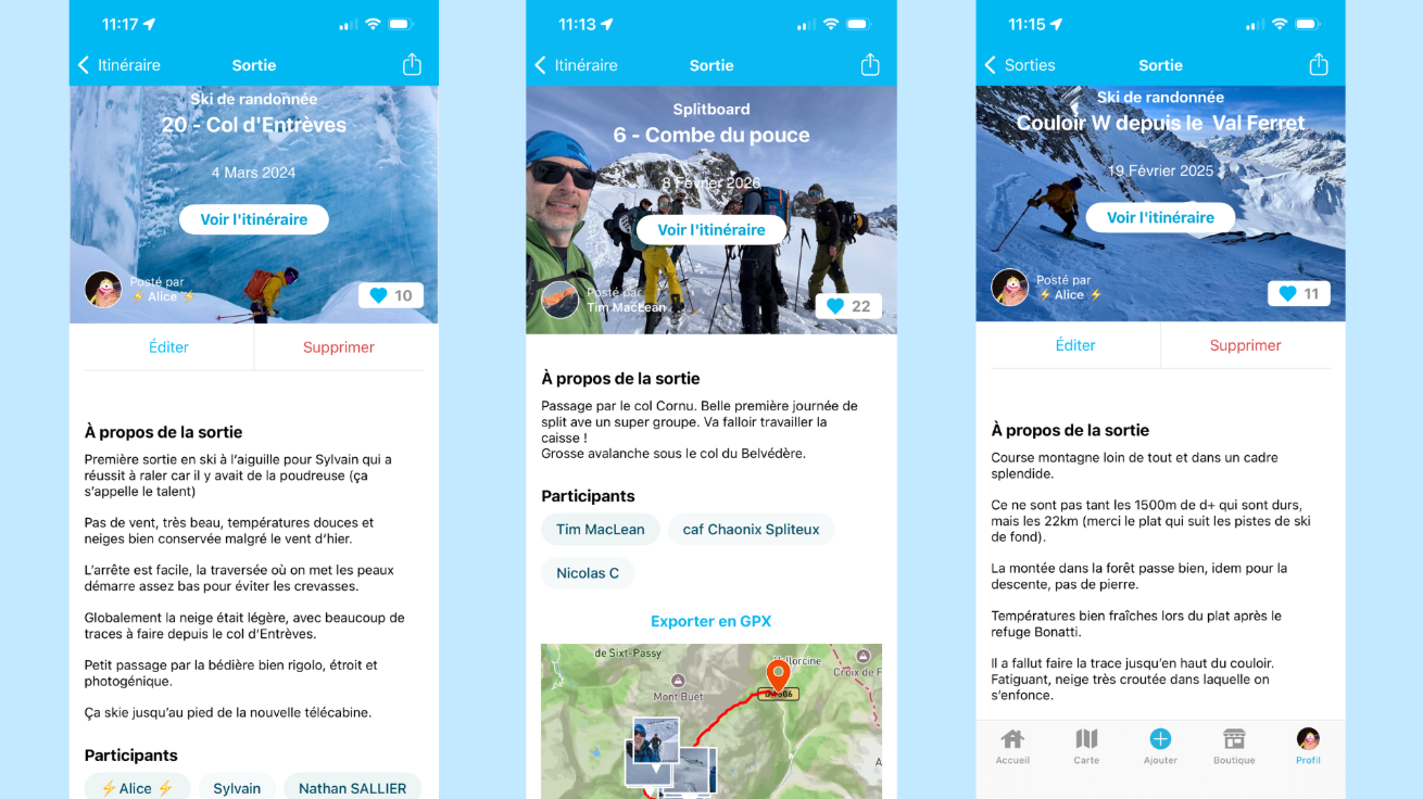
Col d’Entrèves – Vallée Blanche with an Italian twist
- Ascent: 400 m
- Descent: 3100 m (when snow allows skiing down to Chamonix)
- A Vallée Blanche outing with an added ascent to the border Col d’Entrèves for a change from the classic descent and to admire a different, yet still spectacular, landscape.
- Caution: watch out for crevasses when crossing into Italy.
Combe du Pouce – the wild side of the Aiguilles Rouges
- Ascent: 1250 m
- Descent: 2200 m
- Steep sections in the Aiguilles Rouges (grade 4.3) with almost guaranteed solitude!
- Good snow coverage is required to pass the narrow section above the stream.
- Exposure: grade E3—make sure your skill level is sufficient for the descent.
Need more info to understand ski difficulty ratings? Check out our article: Backcountry Skiing Guide Ratings: Everything You Need to Know.
West Couloir of Aiguille de Malatra – the prettiest descent in the Italian Val Ferret
- The Italian Val Ferret is perfect for tranquility and wild scenery.
- The Malatra Couloir offers a beautiful descent in a wide couloir with an overall slope of around 40°.
- If the Bonatti hut is open, stop by for a break—great atmosphere and good food.
- Tip: watch out for flat sections at the start and end on cross-country ski trails. Stick to the parallel track, because you won’t keep up with the XC skiers! 😂
Skin up and let’s go!
Whether you’re discovering backcountry skiing for the first time or still hitting the small snowfields in June, we hope we’ve inspired you to explore new spots or revisit the classic routes around Mont Blanc.
Backcountry skiing means climbing through breathtaking landscapes, descending away from the crowds, and enjoying a beer (or kombucha, why not) at the end.
These great moments are made even better with the Vamos guidebooks and the Whympr app to help you plan your outings. So, strap on your splitboard or skis, and don’t scare the ptarmigans!
Download Whympr for free now on the App Store and Google Play. ⛰️