
Slope Gradient Layer: Visualize the Terrain at a Glance with Whympr
For all ski touring, hiking, and snowshoeing enthusiasts, Whympr has just introduced a new slope gradient layer to help plan your outings with greater precision. What is a slope gradient layer? Why is it important for preparing a mountain trip? How do you read it correctly? We cover everything you need to know in this article.
What is a slope gradient layer?
In the mountains, the slope of the terrain is crucial information. Whether you’re planning a ski touring trip to avoid avalanche-prone areas, looking for the best snowshoe route, or simply curious where it really climbs, having a reliable slope gradient layer at your fingertips makes a big difference.
Why is knowing the slope gradient important?
Because there’s a huge difference between a 28° slope and a 35° slope -especially in avalanche conditions. With this level of precision, you can spot slope breaks, identify critical zones, refine your route, and anticipate technical sections.
At Whympr, to create a highly accurate layer, we use high-definition elevation data combined with digital elevation models (DEMs). The rendering updates in real time as you zoom on the map, and every pixel corresponds to an actual measurement on the terrain. Technically speaking, it’s impressive - but the idea is simple: provide the most accurate information possible so you can enjoy your outing with peace of mind.
.jpg)
A Resolution That Makes All the Difference
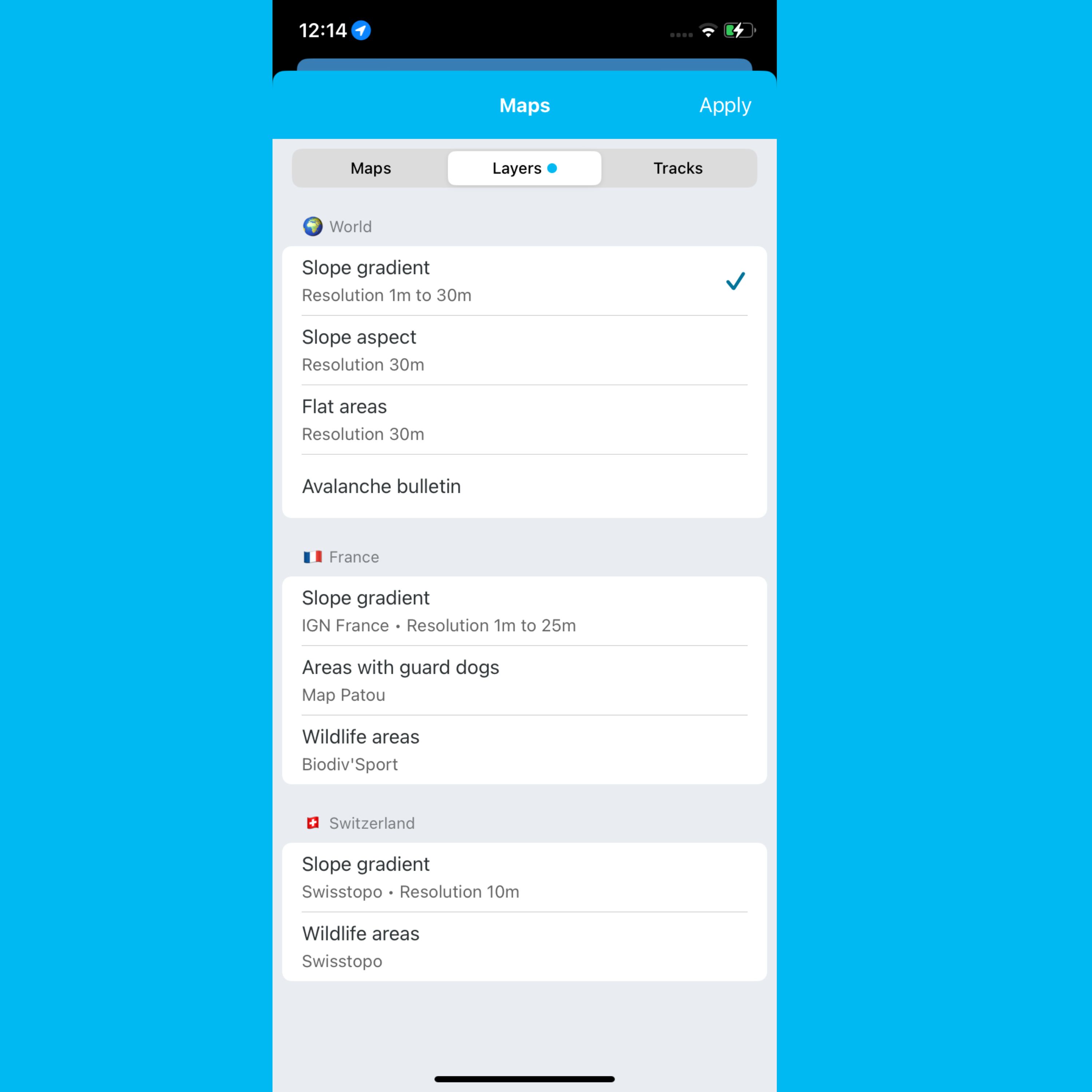
Another important point: the resolution of our layers. In our app, it now ranges from 1 meter to 30 meters depending on the location in the world. Simply put, the lower the number, the more precisely you can observe the terrain’s details and get the exact slope gradient.
- France: 1–5 m
- Italy: 2.5–10 m
- Switzerland: 1 m
- Germany: 1 m
- Austria: 1 m
- Spain: 5 m
- Rest of the world: 30 m
👉 Check the layer legend here for all the details.
We also continue to offer slope data from IGN France and Swiss Topo, so you can cross-check information and compare what the different resolutions provide.
Important Information to Know
As mentioned earlier, slope gradient layers are calculated from digital elevation models (DEMs). They are modeled data, not direct field measurements.
Like all cartographic data, they have limitations, especially in complex terrain (cliffs, slope breaks, glaciers, dense forests, etc.). No source -including national references - can be considered perfectly accurate or exhaustive.
These layers should always be used carefully and cross-checked with other sources: topographic maps, guidebooks, recent conditions, and field observations. They do not replace the experience or judgment of the user.
How it works in the app
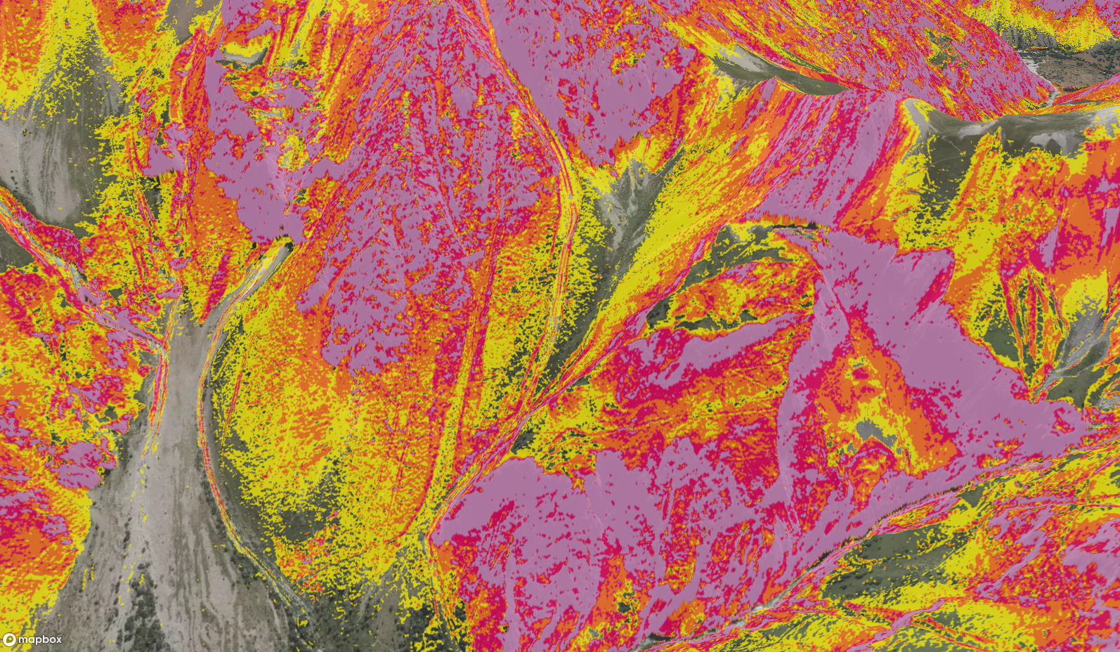
Open Whympr, activate the “Slope Gradient” layer, and your terrain instantly colors according to gradient:
- Yellow: 30–35°
- Orange: 35–40°
- Red: 40–45°
- Purple: > 45°
You can zoom in as much as you like -the precision stays. You can also overlay this layer with other data (routes, huts, weather) to plan your trip with full awareness.
Plan a safer route
With this level of detail, you can:
- Avoid avalanche-prone slopes
- Choose your ascent or descent route according to your skill and preferences
- Anticipate effort: see where it’s steep and where it’s easier
- Share precise trip info with your group
In short, you prepare your outings with a clear view of the terrain.
Exclusive to Whympr
This global slope gradient layer is a Whympr exclusive. We worked hard to make it available because we believe that a great outing starts with excellent digital tools.
So, ready for your next trip?
Download Whympr and activate the layer now with your Premium subscription.


